The Best Place to Live in Marion County, Oregon
By: Melissa Hackenmueller
Moving can be a tough and stressful time and deciding where the perfect place to move to can be even trickier. This poses the question: Where would be the best place to live in Marion County Oregon. The different features needed for this destination city is it needs to have a population larger than 5,000 people but less than 30,000 people. It need to be within 20 miles of a hospital and it needs to be within 10 miles of a park that is at least five square miles large. This criteria would be good for a family that likes more of the small town feel but needs some larger stores near them. It would be ideal for a family with children that might need a hospital in case of emergency or anyone with health issues that needs regular appointments. The last feature of parks, is for an individual or family who enjoys hiking and the outdoors. This is a good start for a family looking to move to Marion County, Oregon.
The most important piece of data that was used to answer the question was the population data. The population of the city that one may choose to live in is very important piece of information. People like different sizes of cities so the cities feature is very important. The other two main features needed to answer this question are hospitals and parks. These two features fit the interests of the person looking to move to a certain area, so they may vary from person to person. The data for these features is from MGIS data folder. The largest concern with this data is that the latest population count is from 2007. That is almost a decade old; this older data might skew the perspective of the cities that are looked at.
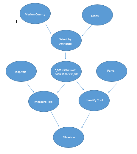
The search for the best city in Marion County, Oregon to live in started with population. The select by attributes tool was used to find cities with more than 5,000 residences but less than 30,000. This narrowed down the choice to only three cities. The next criteria was at least 20 miles from a hospital. Next, the measuring tool was used to find the approximate distances from each city to the nearest hospital. The measuring tool was also used to find the distance from the three cities to the nearest parks. The identify tool was then used to find the square milege of the parks of interest. This process is shown in the flow model below.

From this data and analysis, it was found that Silverton would be the best place in Marion County, Oregon to live. The first step of finding population found out that in 2007 Woodburn had a population of 23,952, Slayton had a population of 7,732, and Silverton had a population of 8,450. The next step of measuring the distance from a hospital found that all three cities were closer than 20 miles to a hospital. Silverton was the closest, only 10.77 miles away from the nearest hospital. Slayton was the next only 13.16 miles away and Woodburn was the farthest but was only 15.61 miles away from a hospital. Finally, the distance from parks and the area of parks was looked at. Silverton was only 0.60 miles away from Silver Falls State Park, which is 35.10 square miles. Woodburn was only 0.28 miles away from Settlemier Park, but this park is only 0.03 square miles. The next closest park to Woodburn is Willamette Mission State Park which is 7.73 square miles but 8.25 miles away from the city. Slayton's closest park was also Silver Falls State Park, but Slayton was 4.58 miles from the park. These three cities are all good candidates, but Silverton was the closest to both a hospital and a park; therefore, it became the best place to live in Merion County.

The overall impression of this project was that ArcMap and geospatial analysis can be used for a variety of things. From helping those in need after a massive earthquake to looking for a good place to live. This project made the many uses very evident. Next time this project is done, the use of most data would be an improvement. Things like schools could be added, if it was a family with young children looking to move or maybe a job would need to be accounted for. More data would improve this project. The largest problem that was faced during this project was the to come up with criteria for this ideal place to live and then to find the data to match up with the criteria. There was some challenges during this project but overall it taught the wide variety of things that GIS can be used for.