Lab 3: Building a Geodatabase
Melissa Hackenmueller
Purpose
and Background
The purpose of this geodatabase is to
organize my final project data. The user of this geodatabase will be only me because
it is for a course project. I chose a file geodatabase, because of the larger
storage space that it has compared to a personal geodatabase. The extent of my
geodatabase is the state of Minnesota. The largest my final map will be is
about 1:400,000 (tri-county area around White Bear lake) and the closest extent
about 1:50,000 (just White Bear Lake). The projection of the geodatabase is NAD_1983_UTM_Zone_15N.
I didn’t incorporate topology or annotations to my geodatabase, because neither
are necessary for the organization of my project. My project doesn’t include
integrated road systems, where topology is required. My project doesn’t need
extensive labeling so annotations are not needed. All
of my data is from various government sources, so all has extensive metadata
included. I don’t plan on expanding this metadata for my project because my
work will not be used in future work as it is for a course project.
Geodatabase
Organization
Feature Datasets
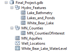
I created two feature datasets
within my geodatabase. The first called Hydro_Features. This dataset includes
three feature classes. They are Lake_Bathmetry, Lakes_and_Ponds, and White_Bear_lake.
The data inside of the Lake_Bathmetry feature class is lake contours for a
majority of Minnesota lakes. The attribute fields include depth, absolute
depth, lake name, and shape length. The Lakes_and_Ponds features class includes
all lakes and ponds polygons in Minnesota. The attributes of this feature class
include DNR identification numbers, acres, shore mileage, city name, shape
length, and shape area. The last feature class in the Hydro_Features dataset in
the White_Bear_Lake feature class. This includes the same attributes and the
Lakes_and_Ponds feature class.
The next feature dataset I created
is called MN_Counties. This includes the MN_CountiesOfInterest feature class.
The MN_CountiesOfInterest feature class includes the counties surrounding White
Bear Lake. The attributes includes the county code, county name, another
identification code, shape area, and shape length.
Features Classes
I included two feature classes within my
Final_Project geodatabase. These two feature classes are MN_Aquifers and
Well_Locations. MN_Aquifers are polygons that represent the top aquifer of that
region. The attributes include area, perimeter, bedrock hydrogeology code, and
bedrock hydrogeology key. The Well_Location feature class is a point feature
class that shows the location of all wells in the state of Minnesota. The
attributes in this feature class include the county code, the location in
township and range, the elevation of the site, the drill depth, drill date,
other drill information, and aquifer the well is drilled in. I also included a
table into my geodatabase called White_Bear_Lake_WaterLevel. This table
included water level data of the lake since the 1920’s and is essential to the
completion of my project.
Behavior
Settings
The behavior settings that my geodatabase
includes are the default values of the feature database and feature classes.
The default XY tolerance used for my feature datasets is 0.001 meters, the Z
tolerance is 0.001, and the M tolerance is 0.001. The default XY tolerance that
I used for my feature classes is 0.001 meters. I didn’t use any other behavior
settings because I didn’t feel that subtypes or domains were needed for my
project, as I will not be adding excess information to my feature classes.
Conclusion
The geodatabase that I have created for
this final course project is a simplistic way to organize the data and the
results that I have compiled. It is composed of two features datasets that
contain feature classes within them, two stand-alone feature classes, and a
table. It contains no topology or annotations and has minimal behavior settings,
but it is fitting for the project that I am conducting.

No comments:
Post a Comment